Houston Flood History and What It Teaches About Urban Survival
Houston’s flood history reflects the challenges of building a major city on a flat coastal plain with heavy rainfall and rapid development. Over time, storms, infrastructure decisions, and urban growth have shaped how the region prepares for and responds to flooding. Understanding this history provides valuable lessons in urban survival, preparedness, and long-term resilience for both residents and policymakers.
Why Is Houston So Flood-Prone? Geography and Climate
Houston’s flood risk is driven by a combination of geography, climate, and development patterns. The region sits on a low-lying coastal plain with clay-heavy soils that absorb water slowly, increasing runoff during storms. The city’s network of bayous—including Buffalo Bayou, Brays Bayou, and Greens Bayou—helps move water toward the Gulf of Mexico, but these channels can become overwhelmed during intense rainfall. Houston also receives high annual rainfall, often exceeding 45–50 inches, and is vulnerable to tropical storms and hurricanes. As urban development has expanded, natural prairie and wetlands that once absorbed water have been replaced by roads and buildings, increasing the volume and speed of runoff. Together, these factors make flooding a recurring challenge that requires both infrastructure and community preparedness.
Early Flooding Events and Regional Impact
View this post on Instagram
Before modern flood control systems were in place, the Houston region experienced repeated flooding events that highlighted its vulnerability. The 1900 Galveston Hurricane, while centered on the coast, affected surrounding areas and demonstrated the destructive potential of Gulf storms. In the early 20th century, heavy rainfall events and river flooding—including the 1935 Buffalo Bayou flood—caused widespread damage in Houston and surrounding communities. These events underscored the need for coordinated flood management and infrastructure planning. Repeated flooding during this period led to increased awareness of the region’s risks and the importance of long-term solutions.
How the 1935 Flood Led to Modern Flood Control
The 1935 flood marked a turning point in Houston’s approach to flood management. After severe flooding along Buffalo Bayou, local and federal leaders moved to establish coordinated flood control efforts. This led to the creation of the Harris County Flood Control District (HCFCD) in 1937, which continues to manage drainage and flood mitigation projects across the region. In partnership with the U.S. Army Corps of Engineers, major infrastructure projects followed, including the construction of the Addicks and Barker reservoirs west of Houston. These systems were designed to temporarily hold stormwater and reduce downstream flooding. While effective in many cases, these structures were built for a much smaller city, and ongoing growth has placed additional strain on their capacity.
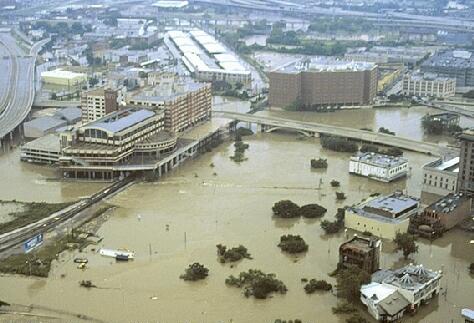
Major Flood Events: Allison and Harvey
View this post on Instagram
Two of Houston’s most significant modern flood events—Tropical Storm Allison (2001) and Hurricane Harvey (2017)—revealed the limits of existing infrastructure. Tropical Storm Allison stalled over the region, dropping more than 30 inches of rain in some areas and causing billions of dollars in damage. It remains one of the costliest tropical storms in U.S. history. Hurricane Harvey brought even more extreme rainfall, with some locations recording over 50 inches. The storm caused widespread flooding across the Houston area, damaging hundreds of thousands of homes and displacing many residents. These events demonstrated how slow-moving storms and prolonged rainfall can overwhelm even large-scale flood control systems.
Infrastructure Challenges: Bayous, Reservoirs, and Growth
Houston’s flood infrastructure—including bayous, reservoirs, and drainage systems—faces ongoing challenges due to population growth and land development. The Addicks and Barker reservoirs, for example, were designed decades ago when surrounding areas were largely undeveloped. As neighborhoods expanded into these regions, more properties became vulnerable during extreme rainfall events. Urbanization has also increased impervious surfaces, such as roads and parking lots, reducing natural absorption and increasing runoff into bayous. While controlled releases from reservoirs during major storms can help prevent structural failure, they may also contribute to downstream flooding, highlighting the complexity of flood management decisions.
How Development Changed Houston’s Natural Flood Protection
Houston’s original landscape included prairies, wetlands, and meandering waterways that naturally absorbed and slowed floodwaters. As development expanded, many of these natural features were replaced or altered. Channelization projects straightened and deepened bayous to improve drainage, but these changes also reduced the land’s natural ability to hold water. The loss of green space and wetlands has made the region more dependent on engineered solutions, increasing the importance of planning, zoning considerations, and sustainable development practices.
What Houston Floods Teach About Preparedness and Survival
Houston’s flood history offers important lessons for individuals and communities. Preparedness plays a critical role in reducing risk. This includes understanding your property’s flood zone, maintaining emergency supplies, and having a clear evacuation plan. During major events like Hurricane Harvey, community efforts—such as volunteer rescue groups—helped support official response systems. These experiences highlighted the importance of neighbor-to-neighbor support and local coordination. Access to safe shelter, reliable information, and early decision-making can significantly improve outcomes during flooding events.
Modern Solutions: Buyouts, Detention Basins, and Green Infrastructure
In recent years, Houston has adopted a range of strategies to reduce flood risk. Property buyout programs allow the city or county to purchase repeatedly flooded homes and convert the land into open space or detention areas. Projects like the Brays Bayou flood control improvements have expanded channel capacity and added stormwater storage. Green infrastructure—such as parks, wetlands, and detention basins—helps absorb excess water while providing community benefits. These approaches reflect a shift toward combining engineering solutions with natural systems to improve long-term resilience.
Conclusion
Houston’s flood history highlights the challenges of living in a region shaped by water, but it also shows how communities adapt and improve over time. From early disasters to modern infrastructure projects, each event has contributed to a better understanding of risk and preparedness. By combining infrastructure investment, responsible development, and personal preparedness, Houston continues to build resilience against future flooding.